10.802 Urban-Agricultural Conflict Mitigation in Urban Reserve.
The regulations in this section apply only to urban land in the urban growth boundary that was added from the urban reserve shown in the Regional Plan Element of the Comprehensive Plan. For other land in the City, development is subject to the agricultural buffering standards in Section 10.801. The basis for these regulations can be found in the Greater Bear Creek Valley Regional Problem-Solving Plan (Regional Plan), Volume II, Appendix III.
(1) Purpose. The purpose of these standards is to mitigate the potential for conflict between farming activities and urban uses. These provisions implement a policy mutually adopted by the City and Jackson County in the Regional Plan Element of the Comprehensive Plan. The mitigation provisions of this Section seek to achieve the following objectives:
(a) Minimize the impacts of urban development on agricultural production activities.
(b) Minimize the potential for complaints about agricultural practices and activities.
(c) Ensure the continued use of agricultural land for agricultural uses.
(d) Minimize potential conflict by developing a well-defined boundary between agricultural and urban uses. The best boundary will be one that minimizes conflict in both directions.
(2) Definitions. The following definitions apply only to this Section.
(a) Agricultural land uses. The use of land for the cultivation and husbandry of plant and animal products, including agricultural activities permitted on land zoned Exclusive Farm Use (EFU).
(b) Classification, Agricultural
(i) Intensive Use (I). The agricultural lands in this category:
(A) Are composed of Class I–IV agricultural soils; or
(B) Support existing or scheduled plantings of long-term crops with a height at maturity exceeding four (4) feet.
(ii) Passive Use (P). The agricultural lands in this category:
(A) Are composed of predominately Class IV soils, can demonstrate an unbroken or essentially unbroken 25-year history of agricultural inactivity or grazing use, and which have either of the following: (1) greater than 50% hydric soils or (2) greater than 50% shallow soils (surface to bedrock) of less than two feet in depth; or
(B) Are composed of greater than 50% of Class VI or poorer soil; or
(C) Are outside of an irrigation district’s boundary and outside of areas suitable for future expansion of a district, as determined by the district.
(c) Mitigation area. A management zone of varying size, shape, and characteristics between the two land uses that utilizes combinations of mitigation elements to buffer between agricultural land and urban land uses.
(d) Mitigation element. A physical or legal feature within a mitigation area that mitigates an adverse impact. A mitigation element may consist of vegetation, transportation and utility corridors, natural barriers, deed restrictions, or other natural or man-made features.
(e) Spray drift. Airborne movement of agricultural chemicals onto a non-target area.
(f) Urban Receptor, Sensitivity of:
(i) Urban receptor, Higher-sensitivity (H):
(A) Residential use.
(B) Motel, hotel, or hostel.
(C) Place of worship; public meeting facility.
(D) Childcare center, kindergarten, school, university, or other educational institution.
(E) Medical center or hospital.
(F) Public or quasi-public use, such as library, park, etc.
(G) Other similar uses.
(ii) Urban receptor, Lower-sensitivity (L):
(A) Commercial use, except for any defined as higher-sensitivity urban receptor.
(B) Industrial use.
(C) All other uses not classified here.
(3) Description of Impacts Requiring Mitigation.
(a) Spray Drift. Principally, spray drift is caused by agricultural chemical use, but may be caused by urban use of agrochemicals. Separation between urban and agricultural uses is the preferred tool to mitigate the impact of the spray drift, employing either large setbacks or a combination of smaller setbacks and a tree buffer.
(b) Trespass and Vandalism. Trespass and vandalism are often considered by farmers to be the most serious adverse potential impact to agricultural operations in proximity to urban areas. Climb-resistant, trespass-inhibiting fences and/or hedges in the mitigation area are the means of reducing these impacts.
(c) Odor. Odor is one of the less important agriculture-related adverse impacts. Unless there are site-specific reasons why mitigation of odor is critical (such as the presence of a livestock feed lot), issues with odor are sufficiently addressed by requiring that owners of new urban development within 1,000 feet of the applicable agricultural land receive notice through an explicitly worded deed declaration of the potential adverse impacts to which they will likely be exposed.
(d) Dust, Smoke, and Ash. Like odor, this grouping potential adverse impacts is one of the least important agriculture-related issues in the region, and, like odor, can be addressed by requiring a deed declaration.
(e) Run-off. Stormwater and irrigation run-off arise from both urban and agricultural uses, and can adversely impact agricultural operations as well as urban health and livability. Impacts may be avoided or significantly reduced by employing erosion-prevention and erosion-control measures.
(f) Noise. Noise is an impact arising from agricultural operations. This Section contains no noise mitigation requirements, but applicants are encouraged to consider community design and construction practices that provide some level of noise mitigation. Recommended methods may be found in Appendix III of the Greater Bear Creek Valley Regional Plan.
(4) Applicability.
(a) The provisions in this Section apply to the development permit applications listed below where proposed urban development abuts land zoned EFU at the outer edge of the urban growth boundary and was part of the urban reserve established in the Regional Plan Element. Refer to Regional Plan Element of the Comprehensive Plan for a map of the urban reserve.
(i) Land Division;
(ii) Planned Unit Development;
(iii) Conditional Use Permit;
(iv) Site Plan and Architectural review.
(b) A pre-application conference is required for all applications subject to the provisions of this Section.
(c) Different degrees of mitigation are required of the applicant based on the following factors: the sensitivity of the proposed urban use to agricultural impacts; the impact being buffered; the intensity of uses on the adjacent EFU land; and whether the mitigation area is to be mid- or long-term.
(d) Mitigation elements established under this Section shall not be removed or reduced unless the applicable adjacent EFU land changes to a non-agricultural zoning district.
(5) Application: Agricultural Impact Assessment Report. As part of any land use or development application listed in Subsection D where the agricultural mitigation standards in Subsections 8–13 apply, an applicant shall supply the Planning Department with a report entitled “Agricultural Impact Assessment Report” (AIAR). The purpose of the AIAR is to provide the approving authority with sufficient evidence to determine agricultural intensity (active or passive) and to evaluate the applicant’s proposed method of complying with the provisions of this Section. The AIAR shall contain:
(a) Map showing the zoning of land adjacent and within two hundred (200) feet of the property proposed for urban development.
(b) A description of the type and nature of agricultural uses and farming practices, if any, which presently occur on adjacent lands zoned EFU and sources of such information. The information thus required, if applicable, shall include:
(i) Method of irrigation.
(ii) Type of existing agricultural product produced or scheduled plantings within one year of projected development completion date.
(iii) Types of agricultural production and practices for the five preceding years.
(iv) Method of frost protection.
(v) Type of agricultural equipment customarily used on the property.
(c) Detailed information obtained from the U.S. Natural Resources Conservation Service (NRCS) concerning soils which occur on the applicable adjacent lands zoned EFU, and whether the land has access to water for irrigation.
(d) Wind pattern information.
(e) A mitigation plan which includes a description of the measures proposed to comply with the requirements of this Section, a detailed landscaping and irrigation plan for the mitigation area, and a copy of the proposed deed declarations, maintenance covenants, and property owners’ association covenants, conditions and restrictions (CC&Rs).
(f) The persons who prepared said report and all persons, agencies, and organizations contacted during preparation of the report.
(g) All statements shall be documented, sources given as reference, and any other detailed information needed to substantiate conclusions should be provided in the AIAR appendices.
(h) If the applicant is requesting a deviation from the standards of this Section, the Agricultural Impact Assessment Report shall not be deemed to be complete unless accompanied by the Conflict Assessment and Mitigation Study described in Subsection 15 and the recommendation of Jackson County’s Agricultural Buffering Committee, or a letter from Jackson County indicating that no such recommendation is forthcoming.
(6) Review Process.
(a) Using the definitions of the urban and agricultural classifications herein and the evidence of the AIAR, the approving authority shall determine:
(i) Whether adjacent agricultural uses are intensive or passive at the time the urban development application is filed and accepted by the City; and
(ii) Whether the applicant’s proposed mitigation plan meets the standards of this Section.
(b) The approving authority shall approve, approve with conditions, or deny the application based on the AIAR and its proposals and conclusions.
(7) Mitigation Requirements.
(a) All mitigation elements will be sited on urban land unless arrangements have been made with the adjacent agricultural land owner to site some or all elements on agricultural land.
(b) When development results in the creation of new lots, all mitigation areas shall be located in a separate tract or tracts under common ownership, not divided among separate lots.
(c) Mitigation for Intensive Agriculture. To minimize or mitigate the potential adverse impacts associated with the proximity of urban and agricultural land uses, the following measures shall be required when the proposed urban development is adjacent to land which is in intensive agricultural use:
(i) Setbacks as illustrated in subsection 9, Figure 10.802-1, either alone or in conjunction with a tree buffer;
(ii) Tree Buffer as illustrated in Figure 10.802-1 and described in subsections 10 and 11;
(iii) Screening Shrubs (only in conjunction with a tree buffer) as described in subsection 12;
(iv) Trespass-Inhibiting Hedges/Fencing as described in subsection 13;
(v) Deed Declaration. Any portion of the site which lies within one thousand (1,000) feet of an applicable EFU zoning district boundary shall be subject to a deed declaration that requires the owners and all successors in interest to recognize and accept common, customary and accepted farming practices which may produce noise, dust, odors, and other impacts. The deed declaration shall be in a form approved by the City. After the deed declaration is signed it shall be recorded in the official records of Jackson County, and copies shall be mailed to the owners of adjacent agricultural lands zoned EFU.
(vi) Maintenance Program. Mitigation areas shall be subject to a restrictive covenant that provides that the perpetual maintenance of mitigation-related fencing, the perpetual horticultural care and maintenance of trees, shrubs, and hedges that are used for mitigation, and the maintenance of other mitigation elements shall be solely the responsibility of the owners and all successors in interest of property subject to the covenant. The covenant shall be in a form approved by the City. After the covenant is signed it shall be recorded in the official records of Jackson County.
(vii) Runoff. Measures appropriate to the circumstances present shall be required to mitigate adverse impacts by employing erosion-prevention and erosion-control measures during construction, and by an adequate stormwater plan for urban development that takes into account impacts from and on the adjacent agricultural land. Any part of the mitigation may be used for stormwater management.
(d) Mitigation for Passive Agriculture. To minimize or mitigate the potential adverse impacts associated with the proximity of urban and agricultural land uses, the following measures shall be required when urban development is proposed adjacent to land in passive agricultural use:
(i) Setbacks as illustrated in subsection 9, Figure 10.802-1, either alone or in conjunction with a tree buffer;
(ii) Tree Buffer as illustrated in Figure 10.802-1 and described in subsections 10 and 11;
(iii) Screening Shrubs (only in conjunction with a tree buffer) as described in subsection 12;
(iv) Trespass-Inhibiting Hedges/Fencing as described in subsection 13;
(v) Deed Declaration. A deed declaration as described in subparagraph (7)(b)(v).
(vi) Maintenance Program. A restrictive covenant guaranteeing perpetual maintenance as described in subparagraph (7)(b)(vi).
(vii) Runoff. Measures as described in subparagraph (7)(b)(vii).
(e) Existing elements that are consistent with the purpose of the buffer may be incorporated in the mitigation design, as described following:
(i) For mitigation without tree buffers, the requirements of linear distance can be achieved by elements such as the following:
(A) Man-made or natural features such as infrastructure rights-of-way, roads, watercourses, wetlands, rock outcrops, forested areas, and steep slopes;
(B) Non-farmable areas of the agricultural land being buffered (including yards, storage areas, roads, and all structures);
(C) Publicly owned land without consistent present or projected public use (as determined by the public entity owner);
(D) An easement on agricultural land purchased by the applicant;
(E) Other open areas (except undeveloped land zoned for rural residential, commercial, or industrial use) that are considered appropriate to the purpose of the buffer.
(ii) For mitigation with tree buffers the approving authority may allow the requirements to be partially or fully satisfied by existing areas of trees and shrubs, as long as their mitigation effect is essentially the same as that intended by the requirements in this Subsection. If the characteristics of the existing vegetation do not meet the requirements in this Subsection, and cannot substitute in full or in part for an adequate tree buffer, then the area can either be incorporated into the design at half its mitigation value (for example, a 20-foot-wide riparian area would be calculated as 10 feet of tree buffer) or it can be left out of the tree buffer and be calculated at its original width (20 feet of existing vegetation would be considered as 20 feet of bare land).
(8) Alteration or Removal of Mitigation Measures. The mitigation measures required by the approving authority may be altered or removed entirely when the zoning of the applicable adjacent agricultural land is changed from EFU zoning. No alteration or removal of the mitigation elements shall cause the removal of fencing or landscaping which is required to meet other buffering or landscaping requirements.
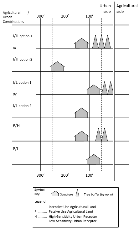
(9) Illustration of Tree Buffer/Setback Combination Options.
(a) Figure 10.082-1 illustrates the tree buffer/setback combination options.
(i) The ‘tree’ symbol illustrates the number of rows required under each option.
(ii) Minimum structure setbacks are represented by the ‘structure’ symbol ranged along a linear scale showing distance from the urban/agricultural boundary. Setbacks apply to any structure. Setbacks do not apply to eaves or similar structural elements.
(b) Figure 10.802-1 does not depict screening shrubs; however, that element is required when a tree buffer is used and the tree species in the first row on the agricultural side will not provide sufficient foliage cover to ground level.
(c) Key to abbreviations used in the Figure:
I | Intensive use agricultural land |
P | Passive use agricultural land |
H | Higher-sensitivity urban receptor |
L | Lower-sensitivity urban receptor |
(d) The letter pairs “I/H”, “I/L”, “P/H”, and “P/L” indicate the types of agricultural/urban adjacencies that determine the extent and make-up of the tree buffer and setback elements. The options shown under each adjacency type may be used at the discretion of the applicant.
(e) Where there is a mix of urban uses, the buffer design shall protect the most sensitive use among them.
Figure 10.802-1. Illustration of Tree Buffer & Setback Options
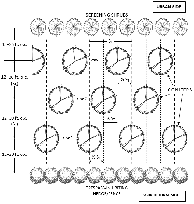
(10) Tree Buffers
(a) Three-Row Buffer (as required for I/H, option 1). Depending on the species used, the minimum allowable tree buffer width is 50 feet; the maximum required is 100 feet. The buffer shall be composed of at least two different conifer species.
Figure 10.802-2. Three-Row Tree Buffer
(b) Two-Row Buffer (as required for I/L, option 1, and P/H, option 1). Depending on the species used, the minimum allowable tree buffer width is approximately 40 feet; the maximum required is approximately 65 feet. The buffer shall be composed of at least two different conifer species.
Figure 10.802-3. Two-Row Tree Buffer
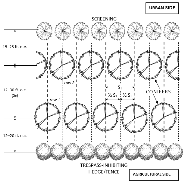
(c) Row Spacing and Offset. The purpose of the row-by-row offset is to mitigate the effect of individual tree mortality and to compensate for the individual differences between trees.
(i) Three-Row Buffer
(A) Offset: Set off the second row by one third the spacing distance of trees (ST) in the first row; set off the third row by another third. Refer to Figure 10.802-2 for clarification.
(B) Spacing of Rows: The distance between rows will be determined using the following formula, where SR is the spacing distance between rows, D1 is the widest foliage diameter of the tree species in one row when it reaches a height of 30 feet, and D2 is the widest foliage diameter of the tree species in the next row when it reaches a height of 30 feet:
SR = 0.5(D1 + D2) + 4
(ii) Two-Row Buffer.
(A) Offset: Set off the second row by half the spacing distance of trees (ST) in the first row. Refer to Figure 10.802-3 for clarification.
(B) Spacing of Rows: Use the same formula as for Three-row Buffers, above.
(d) Tree Spacing within Rows. Tree spacing within a row is based on the greatest foliar diameter of a given tree species when it reaches a height of 30 feet. Coniferous trees vary from narrow pyramidal forms (e.g., Atlas cedar) to broad pyramidal forms (e.g., Norway spruce), so the following table contains calculation methods for each.
|
Higher-Intensity Buffer |
Lower-Intensity Buffer |
|||
|---|---|---|---|---|
|
Narrow ST = |
Broad ST = |
Narrow ST = |
Broad ST = |
|
|
single-species row |
1.25D |
1.1D |
0.95D |
0.8D |
|
two-species row |
0.625(D1 + D2) |
0.55(D1 + D2) |
0.475(D1 + D2) |
0.4(D1 + D2) |
D = Typical foliar diameter of a tree species when 30 feet tall. The diameter is measured at the widest extent of a pyramidal conifer.
ST = Tree spacing within rows; calculated as a multiple of tree diameter.
Note: When planting more than two species in a row, use the two species with the widest diameters to calculate spacing.
(e) Minimum Tree Height at Planting: 5–6 feet, balled and burlapped.
(f) Permitted Tree Species.
(i) Applicants may use any species of conifer trees provided they are resistant to or will not harbor agriculturally harmful insects or diseases.
(ii) A list of recommended species is available in the Greater Bear Creek Valley Regional Plan, Appendix III, available in the City of Medford Planning Department.
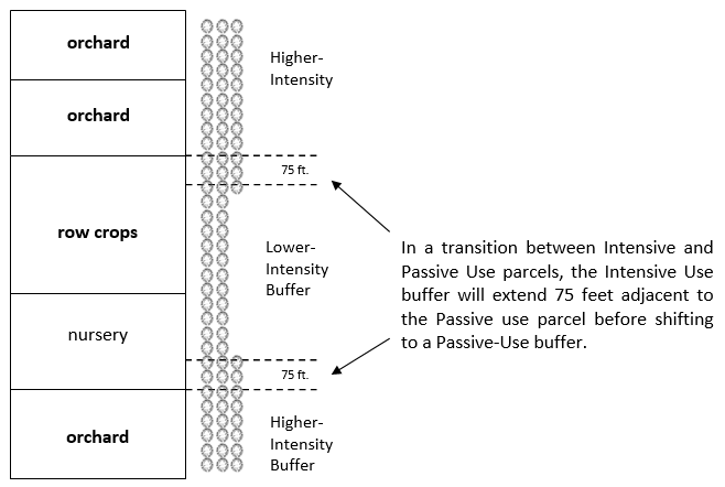
(11) Transitions between buffers of different intensity. The principal purpose of the tree buffer is to mitigate spray drift; spray height is the primary factor in determining whether a higher- or lower-intensity buffer is required. To lessen the amount of spray being carried past a transition between the two types of buffer, the applicant will extend the buffer 75 feet beyond the end of the higher-intensity buffer, as shown in Figure 10.802-4.
Figure 10.802-4. Buffer Overlapping for Transition Areas
(12) Screening Shrubs.
(a) Screening shrubs are used only in conjunction with tree buffers.
(b) If the first row of trees on the agricultural side of the tree buffer does not have foliage down to ground level, install screening shrubs is to provide sufficient foliage cover to close the gap. If the first row of trees on the agricultural side of the buffer provides foliage down to ground level, then screening shrubs are not required.
(c) The mature height of the shrubs shall be 125 percent of the anticipated ground-to-foliage bare space of the average mature specimen of tree species.
(d) Permitted Screening Shrubs.
(i) Applicants may use any species of screening shrubs provided they are resistant to or will not harbor agriculturally harmful insects or diseases.
(ii) A list of appropriate species is available in the Regional Plan, Appendix III.
(13) Trespass-Inhibiting Hedges and Fences.
(a) Hedges and fences may be used separately or in combination to inhibit trespass onto agricultural land.
(b) Hedge Standards
(i) Spacing and Number of Rows: one or more rows, whichever is sufficient to create an eight-foot-wide (8’) buffer at maturity.
(ii) Spacing within Rows: as appropriate to eliminate gaps within three (3) years of planting.
(iii) Overall Height:
(A) No less than five (5) feet if being used solely as a trespass inhibitor.
(B) If doubling as screening shrubbery, the hedge shall cover any bare space between the ground and the lowest branches of trees in the central portion. Mature height shall be 125 percent of anticipated ground-to-foliage bare space of average mature specimen of tree species being screened.
(iv) Permitted Trespass-Inhibiting Species. Applicants may use any species of trespass-inhibiting hedges provided they are resistant to or will not harbor agriculturally harmful insects or diseases. A list of appropriate species is available in the Regional Plan, Appendix III.
(c) Fence Standards
(i) Minimum fence height: six (6) feet.
(ii) Fences shall be climb resistant.
(iii) Install gates only when necessary for maintenance of the mitigation area.
(14) Other Design Requirements.
(a) Mid-term mitigation area
(i) The agricultural land being protected by a mid-term buffer may eventually be converted to urban uses; therefore, a mid-term buffer may be designed for eventual conversion to urban uses.
(ii) Mid-term buffer design shall be based on the following factors:
(A) The most likely time period it will remain as a buffer;
(B) The specific use to which the buffer will likely be put to once the agricultural land is urbanized: conversion to housing, to roads, or to recreational use for the community.
(iii) Alternatively, the applicant may defer development of an appropriate portion of the urbanizing land bordering agricultural land until such time as the agricultural land is no longer zoned EFU.
(b) Irrigation. The establishment of an irrigation system is mandatory for vegetative buffers. Must be designed by a licensed professional, and be site and species specific, as appropriate. The operation and maintenance of the irrigation system must be part of the buffer’s overall maintenance plan contained in the maintenance covenant.
(c) Road Placement. It is always preferable to not bisect buffers with roads due to the wind-funneling effect they create. If a road is unavoidable, it should be as narrow as possible, not straight, and should not be oriented to the prevailing wind. It should be noted that even a road with an acceptable orientation and design will permit some degree of increased spray drift to pass through the buffer area, and will also pose a greater risk of trespass.
(15) Deviations from Provisions.
(a) A proposed mitigation area design that deviates from the provisions of this Section may be approved by the approving authority per the process in this Subsection.
(b) In order to propose a mitigation area design that deviates from the minimum standards in this Section, the applicant is responsible for the preparation of a Conflict Assessment and Mitigation Study (CAMS) and submittal of the CAMS for evaluation by an Agricultural Buffering Committee appointed by the Jackson County Board of Commissioners. The Committee may make a recommendation to the City’s approving authority regarding the acceptability of the deviation.
(c) Conflict Assessment and Mitigation Study (CAMS).
(i) The CAMS shall:
(A) Determine the present and likely future agricultural land uses, practices, and activities with the potential to cause adverse impacts to adjacent urban development. Base the determination of likely agricultural practices on factors such as soil type; topography; parcel size, shape, and location; infrastructure; microclimatic conditions; regional agricultural practices and crops; and the farming history of the adjacent agricultural land and surrounding similar parcels.
(B) Determine how the proposed urban development would likely impact the management and operation of nearby agricultural lands. All owners of EFU-zoned land outside the UGB within 1,000 feet of the land proposed for development shall be asked for an interview, and the findings of those interviews shall be included in the CAMS.
(C) Identify the land uses, practices, and activities that may cause adverse impacts and the extent of the impacts, from both the urban use as well as from the agricultural land. Quantify the impacts, where possible, in terms of frequency and duration of activities. As part of this evaluation, the CAMS shall consider the likely future uses determined in (A) above. The buffering mechanisms that are proposed shall be sufficient to accommodate these potential future uses. The current financial viability of a particular crop shall not be considered an important limiting factor in determining potential future use.
(D) Propose a set of mitigation measures that will achieve acceptable buffering outcomes, which may include, but are not limited to, the siting of residences, size and geometry of lots, separation distances, communal open space, vegetation, natural landscape features, acoustic features, and so forth.
(E) Propose the means by which the proposed mitigation measures will be monitored and maintained. This includes responsibility for implementing and maintaining specific features of the buffer areas to ensure continued effectiveness. Acknowledgment of the authority responsible for ensuring compliance with any agreement or covenant shall be plainly cited.
(F) Establish a timeline for the development that establishes when the buffer will be installed.
(ii) The recommendations of the Agricultural Buffering Committee, if any, shall be included in the application. The application shall not be considered complete without such recommendations or a letter from Jackson County indicating that no such recommendations are forthcoming.
(d) The approving authority may accept the recommendation of the Agricultural Buffering Committee in whole or in part and make findings for its acceptance, partial acceptance, or rejection.
(e) Any approval of a deviation does not create a precedent for any subsequent requests for deviations from the standards of this Section.