10.202 Subdivision Tentative Plat.
(1) Application. The subdividing of land shall be subject to the application requirements as herein set forth and shall include both the tentative and final platting requirements. The approval of a tentative plat is a Type II procedure, with the Planning Director being the approving authority for Partitions and Pad lot Developments. The approval of a tentative plat is a Type III procedure, with the Planning Commission being the approval authority for Subdivisions. Final plat approval is a Type I ministerial procedure which relies on compliance with the requirements established at the time of tentative plat approval, and on the requirements set forth in Section 10.162.
(2) Application for Tentative Plat. The tentative plat for each proposed land division shall be filed with the Planning Department.
(3) Form of Tentative Plat and Accompanying Data. All tentative plats shall be clearly and legibly drawn on tracing paper of good quality and prepared by a civil engineer or land surveyor registered in the State of Oregon. It shall have a dimension of not less than 18 inches by 24 inches, and the scale shall be as follows: One inch shall be equal to 50 feet for 20 acres or less, and one inch shall be equal to 100 feet for all divisions of land over 20 acres in area. The tentative plat shall contain the following data:
(a) Proposed land division name (if a subdivision), date, north arrow, scale, total acreage, and sufficient legal information to define the boundaries of the proposed development.
(b) A key map located in the upper right hand corner identifying the location of the development relative to section and township lines and to adjacent property and major physical features such as streets, railroads, and waterways.
(c) Names of abutting property owners on all sides, names and widths of adjoining rights-of-way, topographic features and all public improvements on adjacent property located within 200 feet of the project boundary.
(d) Name and address of the owner(s) of record, developer, and engineer or land surveyor registered in the State of Oregon who prepared the tentative plat.
(e) Locations, names, widths, approximate intersection angle, centerline radii, center line slopes, and improvement section of all streets, highways and other ways in the proposed project.
(f) Number of lots, dimensions of lots (to the nearest foot), including frontage, width, and area (to the nearest 50 square feet).
(g) Location and height of all existing structures to remain on property and distance from proposed property lines.
(h) Location and character of all easements existing and proposed by the developer for drainage, sewage and public utilities.
(i) Five foot topographic contours describing the area. Where the grade of any part of the proposed land division exceeds 10%, or where the development abuts existing developed lots, an overall conceptual grading plan shall be required showing features adjacent to the development within a reasonable distance therefrom which could affect said project. Where a conceptual grading plan is required it shall show how runoff of surface water from individual lots will be achieved and the ultimate disposal of all development surface waters. All topographic information shall be based on city data.
(j) A conceptual stormwater facility plan with associated landscape plan, if applicable, pursuant to Sections 10.486(2) or 10.729(2).
(k) Location of all creeks, streams and other watercourses, showing top of existing bank and areas subject to inundation as shown on the latest Federal Flood Rate Insurance Maps.
(l) Existing wells and irrigation canals, active or abandoned, and proposed disposition.
(m) Public or common area proposed, if any.
(n) The approximate distance to, and location of, the nearest sanitary sewer main.
(o) Name of the irrigation district, if any, within which the project is located and whether it is currently being assessed.
(p) Name of the school district within which the project is located.
(4) Expiration of Tentative Plat Approval.
(a) Approval of a tentative plat application shall take effect on the date the final order for approval is signed, unless appealed, and shall expire two years from the effective date unless the final plat has been approved by the Planning Director pursuant to Section 10.158. If a request for an extension of a tentative plat application approval is filed with the Planning Department within two years from the date of the final order, the Planning Commission shall grant an extension not to exceed one additional year. Extensions shall be based on findings that the facts upon which the tentative plat application was first approved have not changed to an extent sufficient to warrant re-filing of the application.
(b) When it is the developer’s intent to record and develop a tentatively platted land division in phases, the Planning Commission may authorize a time schedule for platting the various phases in periods exceeding one year, but in no case shall the total time period for platting all phases be greater than five years without having to re-submit the tentative plan. Phases platted after the passage of one year from approval of the tentative plat will be required to modify the tentative plat as necessary to avoid conflicts with changes in the Comprehensive Plan or this chapter.
(5) Land Division Approval Criteria. The Planning Commission shall not approve any tentative plat unless it first finds that the proposed land division, together with the provisions for its design and improvement:
(a) Is consistent with the Comprehensive Plan, any other applicable specific plans thereto, including Neighborhood Circulation Plans, and all applicable design standards set forth in Articles IV and V;
(b) Will not prevent development of the remainder of the property under the same ownership, if any, or of adjoining land or of access thereto, in accordance with this chapter;
(c) Bears a name that has been approved by the approving authority and does not use a word which is the same as, similar to, or pronounced the same as a word in the name of any other subdivision in the City of Medford; except for the words "town", "city", "place", "court", "addition", or similar words; unless the land platted is contiguous to and platted by the same applicant that platted the land division bearing that name; or unless the applicant files and records the consent of the party who platted the land division bearing that name and the block numbers continue those of the plat of the same name last filed;
(d) If it includes the creation of streets or alleys, that such streets or alleys are laid out to be consistent with existing and planned streets and alleys and with the plats of land divisions already approved for adjoining property, unless the Planning Commission determines it is in the public interest to modify the street pattern;
(e) If it has streets or alleys that are proposed to be held for private use, that they are distinguished from the public streets or alleys on the tentative plat, and reservations or restrictions relating to the private streets or alleys are set forth;
(f) Will not cause an unmitigated land use conflict between the land division and adjoining agricultural lands within the EFU (Exclusive Farm Use) zoning district.
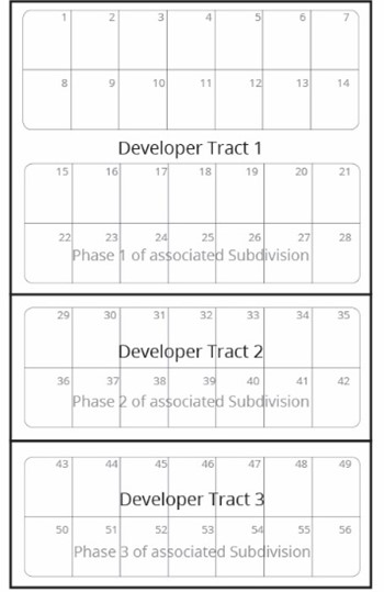
(6) Developer Tracts. The purpose of creating developer tracts is to create lawful units of land consistent with phases of an associated subdivision with tentative plat approval.
When developer tracts are proposed to be created as part of a tentative plat, in addition to the land division approval criteria found in Section 10.170(4), Partition Approval Criteria, or subsection (5) of this section, Land Division Approval Criteria, all of the standards and limitations listed below apply.
(a) Developer tracts must match the phase lines of an associated subdivision with tentative plat approval. The developer tract plat application may be submitted concurrently with or subsequently to the associated tentative plat application.
(b) The title of the final plat for the developer tracts must include the words “Developer Tracts” and the Planning Department file number. The Declarations Section must include the associated subdivision name, the subdivision phase the developer tract coincides with, and Planning file number.
(c) Developer tracts may exceed the maximum area standards of the underlying zone and are not subject to density requirements in Section 10.708 or through lot standards in Section 10.704.
(d) If a developer tract does not have frontage on a public street as required in Section 10.702, a reservation for right-of-way and utilities shall be provided in accordance with Section 10.476.
(e) No new vertical construction shall occur on developer tracts. Prior to final plat approval of the developer tract plat, a deed restriction document, in a form approved by the City, shall be recorded for each new lot or parcel. The deed restriction shall prohibit the installation of individual utility service connections and all new development, including a single-family residence, unless and until a future development approval for the developer tract has received final plat approval of the associated subdivision per Section 10.162 that meets the minimum density standards of the underlying residential zone or has received other required land use review approval.
(f) The expiration of a developer lot tentative plat shall follow the same expiration as listed in Section 10.170(5) for partitions and subsection (4) of this section for subdivisions.
(g) A revised subdivision plat layout may be submitted for approval of the associated subdivision, but the access points and utility connection points to adjoining properties must remain in the same locations unless it is determined by the approving authority that revised locations ensure sufficient access, frontage, and utility connections. If there are any associated reservations for right-of-way and utilities, the City may consent to the extinguishment as per Section 10.476(3).
(h) The final plat of the developer tract shall follow the requirements as listed in Section 10.162.
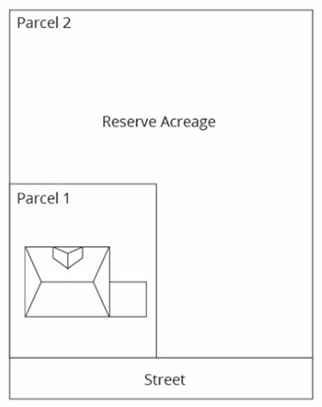
(7) Reserve Acreage. Reserve acreage allows for the creation of oversized parcels or lots that can be further developed at a later time. Reserve acreage may be used to divide property into manageable sizes for development proposals. It is distinguished from developer tracts in that reserve acreage does not have an associated subdivision approval.
When reserve acreage is proposed as part of a tentative plat, in addition to the land division approval criteria found in Section 10.170(4), Partition Approval Criteria, or subsection (5) of this section, Land Division Approval Criteria, all of the standards and limitations listed below apply.
(a) Resulting reserve acreage parcels must be a minimum of twice the maximum lot area and twice the minimum lot depth or width of the underlying zone for residentially zoned properties, other than SFR-00.
(b) Reserve acreage parcels created as part of a land division shall be labeled as reserve acreage on the tentative and final plat.
(c) Reserve acreage parcels and lots are not subject to density requirements in Section 10.708 or through lot standards in Section 10.704.
(d) A conceptual plan is required to be submitted demonstrating how the property can be further developed or divided in the following instances:
(i) When existing structures and uses are planned to remain on reserve acreage parcels.
(ii) When the resulting reserve acreage parcel is less than five net acres.
(e) Street frontage requirements for reserve acreage is as follows:
(i) If the resulting reserve acreage property is less than five net acres, street frontage is required for each new reserve acreage parcel as required in Section 10.702.
(ii) If the resulting reserve acreage parcel is five net acres or more and does not have frontage on a public street as required in Section 10.702, a minimum of a 22-foot-wide private access easement shall be required to ensure vehicular access will be available to all adjoining units of land. The easement may be located in a specific location or a blanket easement. The easement shall only be extinguished when a street is dedicated to the City as part of a future development approval that ensures access to all adjoining properties.
(f) No new vertical construction shall occur on reserve acreage. Prior to final plat approval, a deed restriction document, in a form approved by the City, shall be recorded for each new lot or parcel. The deed restriction shall prohibit the installation of individual utility service connections and all new vertical construction, including a single-family residence, unless and until a future development approval for the entirety of the reserve acreage:
(i) Has received approval of City zoning, other than SFR-00, that matches the underlying General Land Use Plan map designation; and
(ii) Has received final plat approval per Section 10.162 that meets the minimum density standards for the underlying residential zones or received other required land use review approval.
(g) Standards for Dividing Land Zoned SFR-00 into Reserve Acreage.
(i) Properties may be divided into reserve acreage parcels within the SFR-00 zone when the resulting acreage after the land division will create parcels no less than the following:
General Land Use Plan | Minimum Acres per Unit of Land |
|---|---|
Any nonresidential designation | 10 resulting net acres |
UR, UM, UH | 20 resulting net acres |
(ii) The requirements in subsections (7)(b), (7)(c), (7)(d), (7)(f), (7)(g), (7)(h) and (7)(i) of this section apply.
(iii) If the resulting reserve acreage property does not have street frontage as required in Section 10.702, a minimum of a 22-foot-wide private access easement shall be required to ensure vehicular access will be available to all adjoining units of land. The easement may be located in a specific location or a blanket easement. The easement shall only be extinguished when a street is dedicated to the City as part of a future development approval that ensures access to all adjoining properties.
(h) The final plat of the reserve acreage shall follow the requirements as listed in Section 10.162.
(i) The expiration of a tentative plat with reserve acreage shall follow the same expiration as listed in Section 10.170(5) for partitions and subsection (4) of this section for subdivisions.